The lay of the land
Where the valley sits
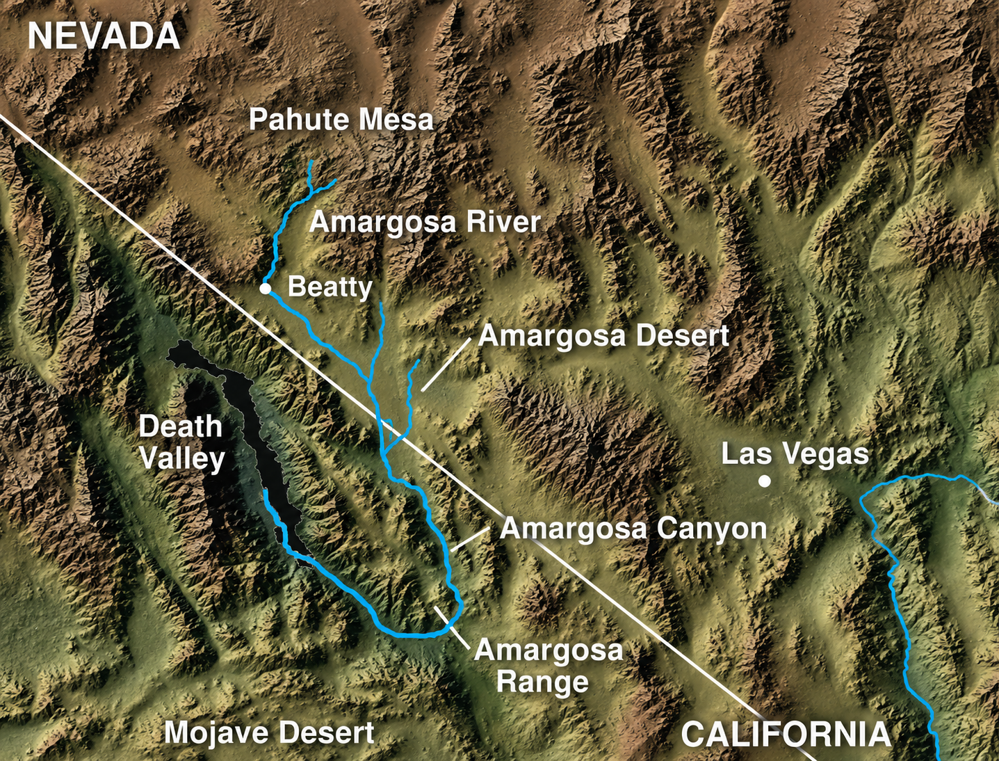
The populated area of the Amargosa Desert is sandwiched between U.S. 95 to the north, and the California border to the south. Some of the residential streets in the community cross over into California. Much of the Nevada-California border in this area is contiguous with the boundaries of Death Valley National Park.
The principal highways serving Amargosa Valley are U.S. Route 95 which runs north-south (NE-SW as it passes through Amargosa) connecting Las Vegas and Reno, and State Route 373, which runs north-south connecting Amargosa Valley to Death Valley Junction via California State Route 127.
Getting here
How far is it?
Out your front door
Things to see and do
Ash Meadows National Wildlife Refuge
The largest remaining oasis in the Mojave Desert, and a wetland of international importance. Springs fed by fossil water left over from the last ice age support the highest concentration of endemic species anywhere in the United States. Three points of interest have wheelchair-accessible boardwalks, restrooms and interpretive signs, and there is a visitor center with interactive exhibits.
Devils Hole
A water-filled cavern more than 500 feet deep whose bottom has never been mapped, and the only natural home of the endangered Devils Hole pupfish. It is a 40-acre detached unit of Death Valley National Park sitting on the Nevada side, and a window into the aquifer below, and the water has been known to slosh when distant earthquakes hit.
Big Dune (Amargosa Dunes)
Roughly five square miles of sand with dunes rising around 500 feet, managed by the Bureau of Land Management and open for off-highway vehicles. Camping is allowed up to 14 days. It stays something of a local secret through the week, but expect company from other riders on weekends.
Amargosa Opera House & Hotel
In 1967 the dancer Marta Becket found an abandoned social hall at Death Valley Junction, rented it for $45 a month and made it her own theater. Her first show, in February 1968, drew an audience of twelve, so she painted a permanent one on the walls. The murals took four years, the ceiling another two. Performances still run, and there is a hotel and cafe on site.
Longstreet Inn & Casino
Right by the California line on State Route 373, with a hotel, an RV park with full hookups and laundry, a restaurant and bar, a pool and hot tub, a fuel station and a small casino. Billy goats and Canada geese wander the grounds, which is half the reason people stop.
Death Valley National Park
The park boundary runs along much of the state line south of the valley and reaches into Nevada near Beatty, about 30 miles northwest of here. Amargosa Valley is one of the quieter ways in.
Stargazing
No gate, no admission and no season. You walk outside and look up. Our stargazing page has a live moon phase, a countdown to the next meteor shower, a month-by-month guide to what is overhead, and a slider that shows you exactly what light pollution takes away.
Geocaching
There is a cache out here called Amargosa Crater, an ammunition box tucked on a hilltop off Big Dune Road, left in 2017 by a group who camp and ride in the dunes. It is rated easy to find, the walk in is mild, and the view back over the sand is the real prize. High clearance helps on the tracks.
Walking the springs
Three short boardwalks, every one of them wheelchair accessible. Crystal Springs runs 0.9 miles round trip from behind the visitor center out to the blue spring pool. Point of Rocks is half a mile through groves of mesquite, with benches at Kings Pool and a climb to a scenic overlook. Longstreet is a 0.2-mile walk to the stone cabin the gunslinger Jack Longstreet built.
In the community
Organizations & churches
Organizations


Jack E Fisher, NV Post 26, American Legion
775-372-5510 1835 W WhitesandsAmargosa Valley, NV 89020 internvern@yahoo.com
Churches
Running an organization we've missed?
If your club, church or group belongs on this page, let the Town Office know and we'll add you.